


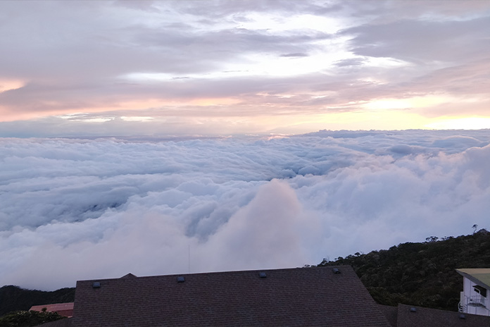
PHOTOS of an island in the clouds in Sabah, East Malaysia, recently went viral on social media.
The photo of Mount Kinabalu taken from a plane had the tip of the tallest peak in Malaysia peeking through a blanket of clouds.
The highest point of Borneo’s Crocker Mountain range rises 4,095 metres above sea level, and pierces the cloudy canopy.
In the right conditions, those willing to scale it are graced with a view like no other.
The High Of Hugh Low
First ascended in 1851 by British colonial administrator and naturalist Hugh Low, Mount Kinabalu has since been kitted out with steps and rest stations to make passage more palatable for the altitude curious.
The price of a guided climb for foreigners is between S$650 and $850, with discounts for larger groups. The prices offered by the various tour companies are competitive, but it’s advisable to book several months in advance.
While accommodation is booked separately, the package includes optional airport pickup, several meals and a bed at the Pabalaban base camp, with a packed lunch for the first day, enough to enable you to focus on climbing and individual preparation. The tour company also awards you with a personalised certificate upon completion.
Pre-covid, tour operators could facilitate many types of excursions, with professional climbers being able to ascend and descend the entire mountain in a single day, the record for which is a mind numbing 2.5 hours.
Post Covid, the Pabalaban base camp can accommodate roughly 150 people per day. Ongoing construction should enable them to facilitate more, but the main hiking trail will inevitably become more crowded.
ALSO READ: The Big Business Behind Ransomware
The Journey Begins
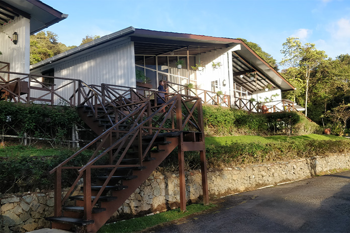
The expedition begins in Kinabalu Park, roughly 90 minutes away from the local airport, which envelops the base of the mountain as a World Heritage site.
The park itself features several trails, a restaurant and many spacious log cabins, a worthy getaway location for those looking to escape city life but disinclined to scale Mount Kinabalu’s incline.
The park’s average temperature range of 15°–24°C makes for hiking-friendly conditions.
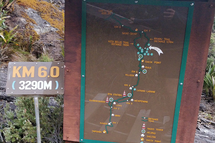
Hikers set off from the park’s Timphon Gate around 8am, making their way through the partial jungle, up the rocky terrain to reach the Pabalaban base camp. While 6 kilometres doesn’t sound substantial, the accompanying change in altitude is around 1,000 metres! Thankfully rest stops placed roughly every kilometre or so can provide shelter from the elements. Most travellers take between 4 to 6 hours to complete this stretch.
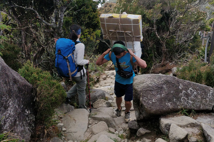
Each group is accompanied by a guide, who encourages travellers to move slowly and stay hydrated to prevent altitude sickness.
Ignore them at your own peril.
Accompanying travellers up the trail are groups of the local Kadazan, who carry your dinner, water, and other supplies to the base camp. The additional niceties along with the linearity of the route make the hike beginner friendly.

The park hosts an array of plants and fauna, but the trail itself is surprisingly calm and only a few of these natural treasures can be easily spotted along the way, the most notable of which are pitcher plants.
As you make your way up through the cloud layer, the damp air begins to condense onto the surroundings and even without rain, you may find yourself becoming damp. The cool atmosphere is a pleasant addition to the otherwise sweaty climb.
Oddities
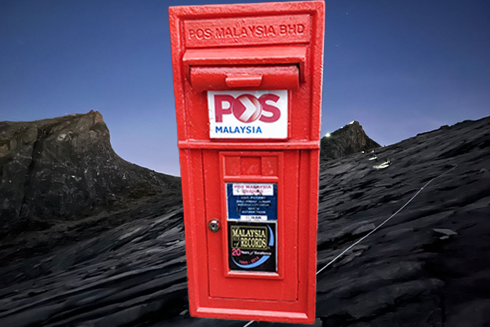
The base camp, which sits just above the clouds, features a few oddities, such as the world’s highest post box.
In the base camp restaurant, where one can snap a gorgeous sunset view, photos of past visitors can be found, including photos of the less fortunate who were injured on the pathway and had to be carried down.
For the egregiously wounded there is a helipad to enable faster response times.
Here, travellers stay overnight in cosy bunkbed and sleeping bag adorned rooms, which are basic but clean and well maintained. The wind can be heard howling through the walls at night. Water shortages may result in a ban on showers at the base camp. Travellers need not worry, as there is always sufficient drinking water provided, and flushing is still permitted. But you may want to carry some wet wipes.
ALSO READ: More Than Just The Message
To Low’s Peak
After a short rest, hikers wake up at 2:30am to begin their climb to the summit, in time to catch the sunrise. A cluster of torch bearers make their way up a series of wooden steps and rock faces. As people gradually spread out, a trail of wavering lights snakes its way up the path before you.
Temperatures on the summit trail can vary between 6°–14°C and can drop as low as 2°C. While many begin the journey heavily wrapped in anticipation of such temperatures, most soon strip off some of their layers as the stair climbing ramps up the body temperature.
But warm clothes and even a balaclava are advised for the summit, which is more exposed to the elements — sharp, cold winds, and should the heavens will it, rain.
The less challenging Ranau trail is the current pathway of choice, the slightly shorter Kota Belud trail is a slightly more treacherous option in the dark. Some parts of the trail were closed off after the 2015 Sabah earthquake and ensuing landslide.
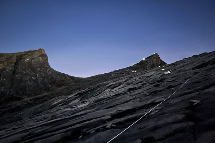
This roughly 3 kilometre trail to Low’s peak takes you up another 1,000 metres, initially with some coverage from surrounding rocks and foliage but eventually climbers are completely exposed as they ascend the stairs and the smooth rock face that leads to the summit.
As you walk up the final slopes under a field of stars, the rock face gently glows beneath.
The summit climb can take between 2 and 6 hours depending on your tenacity to beat the sunrise.
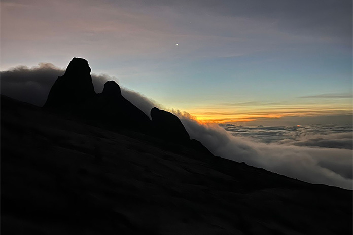
In fact, there is not enough room for all climbers to sit at the tip of Low’s peak, hence most experience the dawn breaking from the plains around 50 metres below. As the sunrise creeps through the cloud layer below, the path scaled in previous hours is gradually illuminated, the distant peaks of the surrounding summit take shape and in the gaps of the cloud layer, Kota Kinabalu, Sabah’s capital, can be seen in the distance.
To Via Ferrata Or Not to Via Ferrata
Visitors have the option to enjoy a partial descent of the mountain via ferrata, where members of your group are fitted with harnesses and linked via a rope, and you gradually make your way across a metal rope-guided pathway with some vertical climbs and rope bridges.
After having climbed a mountain, this may be a little overkill, and it may be better to opt for the shorter version, or skip it altogether. The longer via ferrata route has taken some climbers as long as 16 hours to complete (4 to 6 hours on average), so make sure all in your group are prepared to be tied together for an extended period.
Supposedly, there is a sea of dropped smartphones below these climbing routes, so take necessary precautions to prevent losing your expensive electronics. Thankfully, the accompanying guides will take many photos of your group as you scale the pathway, should you not wish to let go of the ropes.
Do it for the Experience – and the View
Overall, the experience depends heavily on the weather.
Many parts of the climb could become a slog in wetter and windier conditions; even gentle rain can make the many steps much more slippery, and the anticipated view at the peak may be partially obscured.
But these minor inconveniences should not deter you from a rewarding experience, and the ending should not prevent you from enjoying the journey, the opportunity to get closer to nature and visit an island in the clouds, where few have ventured.


